|
Save the file to your device and then rename it by taking out the .txt at its end. Your device will now open it as a gpx file
|
| |||||||
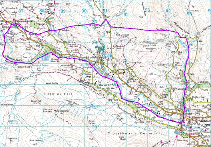
LANDRANGER 92 O/S Crown copyright 2016 CS-30288-W3Z2M1

It is advisable to take a compass with you on this walk. In one section you cross high moorland dotted with abandoned mine shafts and visibility can deteriorate very quickly. In addition, after heavy or prolonged rainfall Wester Beck can become difficult to cross.
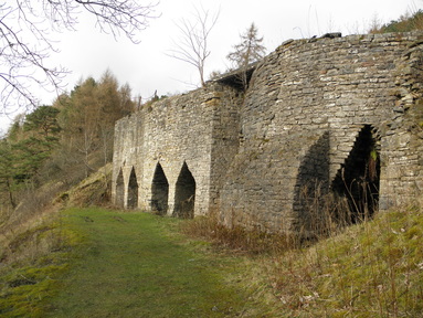
From the Tourist Information Centre walk along Market Place towards Alston. Almost immediately take the road that turns off to the right. It passes the Teesdale Hotel and is signposted ‘Stanhope’. This road leads you past the Victorian parish church of St Mary’s and rises steeply up Town Head, but you leave it fairly soon by taking the road with a no through road sign that runs off to the left (Beck Road). The road leads into the attractive Hudeshope Woods and quickly drops down to Hudeshope Beck. As you walk you pass several small waterfalls and a picnic area. After just over 1/2 a mile you reach Snaisgill Beck running down from your right, immediately followed by a small stone building and then an old quarry on the same side. Continue on until a track swings off to the right up to and around behind the impressive Parker’s Kilns. Built in 1840, there are three sets of twin kilns, the third pair being semi-circular. The limestone was brought down from Skears quarry and burned here to produce lime to spread on the fields to neutralise acidic soils. Continue straight on up a steep slope, passing the quarry on your right and passing back into woodland. Where the path swings right and up a steep flight of steps climb up the steps and ignore the ‘path’ that goes straight on. At the top continue along the top of the wood, ignoring a footpath off to the right, until you reach a wooden stile in a wall ahead, close to a field corner.
Cross the stile into the field and with the wall on your left, follow the wood edge to the next stile (stone) into another field. Again keep close to the wall on your left, but above the mud ! Continue on through a broken down wall, past a stone byre in the field to your left, to arrive at another stone stile in the corner of the field. Cross and continue on the same line, the views of Coldberry now becoming ever clearer, to a wooden gate at the bottom of a wooded gully. Here a pleasant green track leads you down through the lead mines of High Skears. Continue along the track through the old mining remains and two metal gates to reach a wooden gate with an ‘Open Access’ sign alongside it, just above the beck. The track continues along a beautiful section above the tumbling beck, perfect for a short break, and, after passing an old stone building with a corrugated roof, crosses over an arched tunnel just to the right of the building. Continue on to a wooden gate in the stone wall in front and the straight on through two more wooden gates before dropping down to cross Marl Beck. On the far side rise to a wooden stile gate. From here the path is much fainter. Follow the arrow on the gate and head for the wooden finger post footpath sign in the distance, coming out onto the road just to the right of a road sign and a telephone pole.
Turn left and walk down the road towards Hudeshope Beck. Before reaching the beck (unless you wish to explore the extensive remains of Coldberry Mine on the hillside ahead) turn right along a track at a footpath sign. Continue until you come across a path on the left that cuts down to cross Hudeshope Beck on a metal bridge. Once over the bridge turn immediately right over a wooden stile (difficult for dogs) and continue up the right side of first a fence and then a wall and then straight on up to the hilltop, keeping Pikestone Brow farm directly behind you. At this point you will need to use a compass and map or gps device to follow the path in a westerly direction over rough boggy ground for about 1500 yards. At roughly the highest point on the path you will see a reservoir to your left and soon cross a fence via a stile. You now have views over Teesdale with the two white farmhouses ahead of you – the first being Moor House, your next destination. Cross the rough field for about ½ mile down to a stile in the wall (well hidden) then another field and another stile in wall (between 2 yellow poles). Cross this field to a metal gate then up to the farm house. Cross through two further gates round the left hand side to reach the Newbiggin to Westgate road. Turn right and take this road for 500 yards then turn left to follow the track to Broadley’s Gate Farm and just before reaching it turn right through a wooden gate with an open access sign.
[Alternatively on reaching the road go straight across and follow the remarkably well signed footpaths (not as shown on the OS map) down to two solid footbridges and on up to Broadley’s Gate Farm. Here you have to pass over a cattle grid to your right or venture through a couple of gated sheep pens if you have a dog ! - keeping the farm buildings on your left. Just before the farm pass through a wooden gate with an open access sign.]
Once through the gate head west (a few trees on the skyline provide a marker) to reach a kissing gate. Keeping on the same line head down to Wester Beck (after heavy rain this beck can be difficult to cross without getting your feet wet !) by aiming for the bottom of a wall on the opposite side. Cross the beck, climb up the far side and continue to head west. Telegraph poles and a wall in the distance provide a useful guide. Your route eventually passes between the second and third pole to the right of the wall. Pass through two more kissing gates and cross a small stream as you make your way across this section of very rough pasture. Spectacular views open up of the Holwick Fell to your left and the peaks of the North Pennines (including Cross Fell, at 2930 feet the highest hill in England outside the Lake District) ahead. Reaching a ladder stile with an Open Access sign cross over it and continue westwards again, crossing down to a farm track that fords a stream and rises to a metal gate. Continue along the track until you reach Ashdub Farm. Keep the farm on your left, passing through a metal gate into a yard and another gate out again. Follow along the side of a large black barn and at its end head for a stile ahead in the right hand corner of the field. Once over the stile pass to the left of a ruined animal shelter and head down the slope to pick up another farm track. It curls steeply down to cross Etters Gill (footbridge available) and rises up and on behind a farm to come out on a small road. Turn right and in a few yards take the footpath on your left. Walk up towards a black barn and pass through a gate to its right. Cross diagonally to the bottom corner of the field to climb a broken old ladder stile. Again head diagonally to your left to find another very old wooden stile. From here continue on the same line through an old gateway in a broken down wall and finally through another gate onto a tarmaced lane. Turn right along the lane passing a converted Primitive Methodist Chapel on your right.
[Alternatively if you wish to avoid the large worst of the stiles after the black barn cross the field to a gate and passing through head across to the corner of Walker Hill Plantation and through a gateway. From here keep to the edge of the plantation and cross to a stile. Once over, this keeping the same direction, head across the next field. When you reach the wall turn left and follow the field right down to the road with the old chapel directly on your right].
Enjoy the fine views, especially the close up Cronkley Scar to your left as you follow this peaceful lane. Where, at the next farm, the lane swings down to the left keep straight on through a pedestrian gate beside a galvanised farm gate. Continue, with the farm buildings on your left, to a stile. Crossing it you join an old Green Lane with a wall to your left and the remains of another stone wall on your right. Continue, crossing a stile and some reaching a tarmaced lane. Follow this until you reach the Forest-in-Teesdale school on your left. The lane now swings left to take you down to Hanging Shaw parking and picnic area and the main Middleton to Alston road beyond.
Turn right along the road for a few yards and then cross over and follow the footpath sign down the drive to Birk Rigg. Before reaching the farm a clear footpath sign leads you around the right of the buildings and straight down the field to a stile. Crossing a mashy section the path rises to follow to the right of a stream, past some barns and a few yards later arrives at a gate on the right. Passing through the gate the path continues across the field to another gate and then left down a steep slope to a farm bridge over the RiverTees. Cross the bridge and follow the track up the slope towards Cronkley Farm, but instead of entering the yard, go right over a stile and down the side of the wall to reach a stile at the bottom of High Crag. The path slants up a steep slope through the rocks and gorse to a hidden stile. From here follow the side of the wall up to a good viewpoint before descending and crossing a stream and a stile. A little way ahead a path leads off to the right to meet the old Alston to Thirsk drovers’ track in the valley. Ignore this and swing to the left, still following the Pennine Way on a very clear path past first a great Whinstone quarry and then the magnificent High Force waterfall (the highest fall in the country) before arriving at Low Force. From here the path continues closely along the Tees (on your left) for about a mile and a half, until, with Park Fell Wood to your right, it cuts across two meanders. It is well marked throughout this section and for part of it follows a sunken lane., before rejoining the river bank briefly. Finally near East Crossthwaite it leaves the riverside for the last time, passes a stone barn on the left and continues as a clear track to the end of the field and on through the next two until it takes you out onto the road at Middleton. Turn left, crossing the bridge and climbing back up the hill into the village until you reach the Market Place where you can find refreshments in one of the many cafes or pubs.


