Silver Challenge Walk 9
Great Stony Hill & Harwood
Great Stony Hill & Harwood

Save the file to your device and then rename it by taking out the .txt at its end. Your device will now open it as a gpx file
|
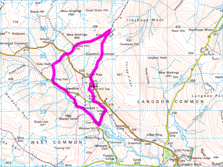
Distance - 6.1 miles Map : OS Explorer OL31 Parking : a lay-by opposite the mast at Hill Top on the B6277 (823 338) | ||
LANDRANGER 92 O/S Crown copyright 2016 CS-30288-W3Z2M1
There are a large number of old mine shafts and sink holes in this area so do not attempt the walk in poor visibility. There are also three
crossings of streams without footbridges.
Walk along the verge the short distance to Trough Sike where you will see a footpath sign off to the right. Go through the gate and follow the path upstream. A landslide will soon force you to cross the beck. Choose your place to cross carefully and look for a route back across as soon as you have passed the landslip. In a short distance the route of main beck turns to the left and a small tributary flows straight towards you. Here climb up the bank on your left to walk along the top past as series of grouse butts towards a large sheepfold. Behind you in the distance you will see Mickle Fell with Little Fell to its right. Further to the north are Meldon Hill, Get Dun Fell (with its prominent weather station), Little Dun Fell and Cross Fell (the highest peak in England outside the Lake District).
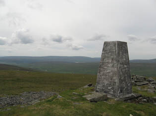
Go around the sheep fold to find the beck, now just a shallow stream, once more. Continue upstream alongside it. Soon a prominent grassy spoil heap will become obvious ahead. Behind it you will find ruins of buildings from old mine works. The peak of Three Pikes is now clear to your right, whilst ahead are a line of grassy mounds containing deep pools. Continue in the same direction. A large cairn should now be clear ahead to your right. Once you can make out a line directly ahead which is the first glimpse of the old road of Grasshill Causeway, begin to work your way over towards the cairn on your right, choosing the driest route possible. As you get close to the cairn you will come to a cut through from the causeway in the bank on your left. Turn and follow it up to the causeway. Here turn right and follow the causeway to the watershed at Coldberry End. If you wish to continue on to the trig point at High Field (708 metres) simply follow the fence on your left for about 10 minutes, alternatively if you would like to look down to Burnhope Reservoir and the valley of Weardale continue along the causeway for another 5 minutes. Should you extend the walk in either of these ways, return to Coldberry End to begin the next stage of the route.
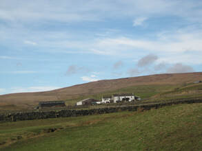
Follow the causeway downhill. In places large amounts of loose stone mean that it is easier and safer to use the grass verges for walking. Pass through a gate and continue on to the B6277. Cross the road to the footpath sign and follow the path downhill with a stream on your right. At the bottom cross a footbridge over Ashgill Beck and follow the path up the next field between a fence and an old wall. Cross a stile into the next field and in the corner ahead go over another stile in the wall on your left. Looking downhill the tops of some trees are visible. Head towards these and the modern barn at Dale Head becomes visible. The path runs over to the left side of the barn and then turns left along the field. Continue through a gate and turn downhill to cross the stream (there is no bridge I’m afraid). Continue downhill to find a stile where the fence and wall meet and on down to pass to the right of a small derelict barn (the white farm house of Frog Hall is further over to your left) and reach the surfaced road at the head of Harwood valley. Turn left until you reach the two farms at Herdship.
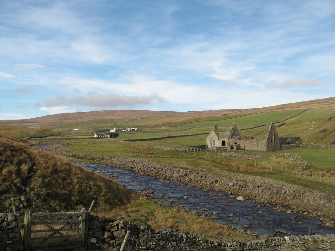
At the farm of Watersmeeting on your right, turn right (following a finger post) into the farmyard and then through a gate on your left to pass between buildings. Ahead of you is a large galvanised gate. Pass through this and cross the field to another gate. Go straight on to cross a stile in the wall ahead, before going across a slab bridge over a sike and rising slightly to reach a track ahead. Here turn right to walk down towards some ruined buildings. These are the remains of Harwood church and school. Pass through a gate on their right out onto the river’s edge and walk along downstream in front of the buildings to reach a substantial footbridge over Harwood Beck.
Rise slightly uphill until you can find a route downstream avoiding the landslip ahead. When the field wall ahead comes into view steadily make your way back down to pass between the beck and the wall. The path follows along the beck side, passing the ruins of Midge Holm before reaching the road at Low End. Turn left over the bridge and follow the road up past the old chapel on your left and eventually Lingy Hill farm on your right to reach a T junction. Here turn left downhill. Just before the first house on your right take the footpath signed on your right. Go through the gate and climb the hill ahead keeping roughly parallel with the B6277 which you can see to your right.Find a gate ahead and continue straight on to find another gate at the back of some old ruins. You are now on a track. Follow it as it angles down to cross Trough Sike at a ford and then swings back up to the B6277. The parking space is just a few yards to your right.
crossings of streams without footbridges.
Walk along the verge the short distance to Trough Sike where you will see a footpath sign off to the right. Go through the gate and follow the path upstream. A landslide will soon force you to cross the beck. Choose your place to cross carefully and look for a route back across as soon as you have passed the landslip. In a short distance the route of main beck turns to the left and a small tributary flows straight towards you. Here climb up the bank on your left to walk along the top past as series of grouse butts towards a large sheepfold. Behind you in the distance you will see Mickle Fell with Little Fell to its right. Further to the north are Meldon Hill, Get Dun Fell (with its prominent weather station), Little Dun Fell and Cross Fell (the highest peak in England outside the Lake District).
Go around the sheep fold to find the beck, now just a shallow stream, once more. Continue upstream alongside it. Soon a prominent grassy spoil heap will become obvious ahead. Behind it you will find ruins of buildings from old mine works. The peak of Three Pikes is now clear to your right, whilst ahead are a line of grassy mounds containing deep pools. Continue in the same direction. A large cairn should now be clear ahead to your right. Once you can make out a line directly ahead which is the first glimpse of the old road of Grasshill Causeway, begin to work your way over towards the cairn on your right, choosing the driest route possible. As you get close to the cairn you will come to a cut through from the causeway in the bank on your left. Turn and follow it up to the causeway. Here turn right and follow the causeway to the watershed at Coldberry End. If you wish to continue on to the trig point at High Field (708 metres) simply follow the fence on your left for about 10 minutes, alternatively if you would like to look down to Burnhope Reservoir and the valley of Weardale continue along the causeway for another 5 minutes. Should you extend the walk in either of these ways, return to Coldberry End to begin the next stage of the route.
Follow the causeway downhill. In places large amounts of loose stone mean that it is easier and safer to use the grass verges for walking. Pass through a gate and continue on to the B6277. Cross the road to the footpath sign and follow the path downhill with a stream on your right. At the bottom cross a footbridge over Ashgill Beck and follow the path up the next field between a fence and an old wall. Cross a stile into the next field and in the corner ahead go over another stile in the wall on your left. Looking downhill the tops of some trees are visible. Head towards these and the modern barn at Dale Head becomes visible. The path runs over to the left side of the barn and then turns left along the field. Continue through a gate and turn downhill to cross the stream (there is no bridge I’m afraid). Continue downhill to find a stile where the fence and wall meet and on down to pass to the right of a small derelict barn (the white farm house of Frog Hall is further over to your left) and reach the surfaced road at the head of Harwood valley. Turn left until you reach the two farms at Herdship.
At the farm of Watersmeeting on your right, turn right (following a finger post) into the farmyard and then through a gate on your left to pass between buildings. Ahead of you is a large galvanised gate. Pass through this and cross the field to another gate. Go straight on to cross a stile in the wall ahead, before going across a slab bridge over a sike and rising slightly to reach a track ahead. Here turn right to walk down towards some ruined buildings. These are the remains of Harwood church and school. Pass through a gate on their right out onto the river’s edge and walk along downstream in front of the buildings to reach a substantial footbridge over Harwood Beck.
Rise slightly uphill until you can find a route downstream avoiding the landslip ahead. When the field wall ahead comes into view steadily make your way back down to pass between the beck and the wall. The path follows along the beck side, passing the ruins of Midge Holm before reaching the road at Low End. Turn left over the bridge and follow the road up past the old chapel on your left and eventually Lingy Hill farm on your right to reach a T junction. Here turn left downhill. Just before the first house on your right take the footpath signed on your right. Go through the gate and climb the hill ahead keeping roughly parallel with the B6277 which you can see to your right.Find a gate ahead and continue straight on to find another gate at the back of some old ruins. You are now on a track. Follow it as it angles down to cross Trough Sike at a ford and then swings back up to the B6277. The parking space is just a few yards to your right.