
|
Bronze Challenge Walk 1:
Old Railway 2.45 miles |

|

|
|
Save the file to your device and then rename it by taking out the .txt at its end. Your device will now open it as a gpx file
|
| ||
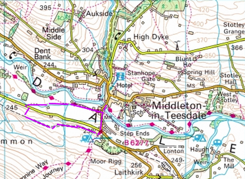
LANDRANGER 92 O/S Crown copyright 2016 CS-30288-W3Z2M1
From there market place return down Bridge Street and cross the old county bridge over the River Tees. Built in 1811, it used to mark the boundary between the counties of Durham and Yorkshire. Walk up the hill until you come to the first road off to the right (signposted Holwick). Turn right and walk to the end of the house on the corner. To your left you will see a footpath sign for the Pennine Way through a wooden gate. Follow this path up a steep slope for about 20 yards and then turn right along a permissive path on an old railway line. This line, opened in there early 20th century and operated until 1951 by North Eastern Railways, was used to transport stone form the quarries of Park End and Crossthwaite to Middleton and from there on to Darlington. Follow the old track for about a mile. It is easy walking and gives beautiful views to the north of the Tees Valley and fells between Newbiggin and Middleton and to the north west of Holwick Scars and beyond.
On reaching a dry stone wall ahead, turn right down a faint path, keeping close to the wall, until you reach a gate out onto the road at the bottom. Turn left along the road for about 200 yards until you see a footpath sign off to the right through a wooden gate. Once through the gate make your way straight ahead towards a bridge over a stream and having crossed turn right. Head for the gateway ahead. Keep on the same line across a second field to find a stile near the far corner. On crossing the stile you will be alongside the stream once more . Follow the bank of the stream through the field and most of the next one, util the path leads up to a track by a stone barn. This is the Pennine Way. Continue a long the track to the end off the field and on through the next two until you come out on the road at Middleton. Turn left, crossing the bridge and climbing back up the hill into the village until you reach the Market Place.
On reaching a dry stone wall ahead, turn right down a faint path, keeping close to the wall, until you reach a gate out onto the road at the bottom. Turn left along the road for about 200 yards until you see a footpath sign off to the right through a wooden gate. Once through the gate make your way straight ahead towards a bridge over a stream and having crossed turn right. Head for the gateway ahead. Keep on the same line across a second field to find a stile near the far corner. On crossing the stile you will be alongside the stream once more . Follow the bank of the stream through the field and most of the next one, util the path leads up to a track by a stone barn. This is the Pennine Way. Continue a long the track to the end off the field and on through the next two until you come out on the road at Middleton. Turn left, crossing the bridge and climbing back up the hill into the village until you reach the Market Place.

Follow us on Facebook!
