THE TEES'POT WALKS
The Tees'pot Walk 2/2 : Brown Dodd & King's Walk

Click here to Download File
Save the file to your device and then rename it by taking out the .txt at its end. Your device will now open it as a gpx file
|
Distance - 5.4 miles
Map : OS Explorer OL31 Parking : Middleton Sports' and Social Club |
| ||
LANDRANGER 92 O/S Crown copyright 2016 CS-30288-W3Z2M1
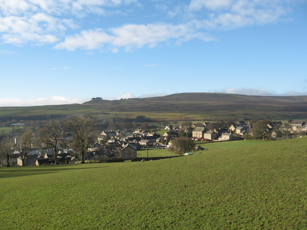
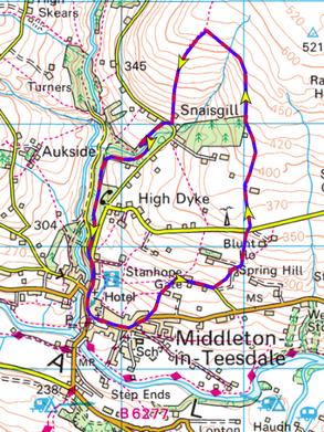
From the market place follow the main road towards Barnard Castle (B6282 ) keeping on the left hand side. Follow the curve of the road round to the left and after the last house on the left, with pots of plants across a driveway, turn left to follow a footpath over a stile on the new wall and keeping to the right. Through another stile and continue up the right hand side of the field to the top.
Here you will find a gate with another stile beside it. Turn right along the track into a farmyard, turn left up between two barns, and go over a wooden gated stile at the top right hand corner. Cross the field to another stile in the right hand corner, take this into a narrow lane, now turn right before Stanhope Gate farmhouse and follow the farm track for two fields until you come to a footpath sign pointing into the field on your left. (there can be cattle in this field). Go through the gate and cross the field to your right to a stile in the wall. Take this and cross the field to the top right to the gate. Go through the metal gate, turn left towards the house, cross the yard to the right and go through a wooden gate.
Now you turn up the field climbing steadily keeping to the wall on your right. Cross the next field still steadily climbing with the wall on your right until you reach the Stanhope road. Go through the gate and turn right onto the road. You will immediately see a footpath sign on the left ahead, go through the gate into the field.
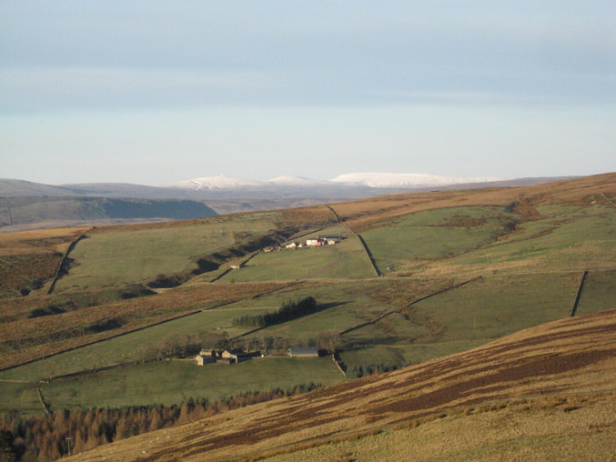
Take the footpath to a gate in the fence ahead and then to the next gate in a all corner diagonally opposite. From here, keeping the wall close to your left, climb up the hill until your path is blocked by a wooden gate. Take advantage of the views behind you of Lunedale with its two reservoirs and of the Tees Valley down to Romaldkirk before you exchange them for views north of Middleton after the next stile. Once through the gate continue to climb steadily over rough pasture to an old ruined barn in the top left hand corner of the last field next to a small plantation. The path can be boggy here so you might want to take the track straight up and then turn left along next to the wall.
At the ruined barn go through the stone building attached to the rear following the signs into a large field. From here there are superb views across to Aukside and Coldberry Gutter, up Teesdale and beyond to the highest peaks of the North Pennines (indeed, outside the Lake District, the highest peaks of anywhere in England). Now follow the faint track keeping a few yards left of the stone wall along the top of the field. You will have a small beck to cross then Snailsgill Sike, in a deeper ravine. Keep to the wall until, just after a gate on your right, you come to a stile where the wall turns sharp right. Ignore this tempting path over the wall onto Monk’s Moor and instead turn diagonally left on a faint path to meet, in a few yards, a track down the hillside. Follow the track down to a metal gate and on until you are level with another metal gate in the wall to your left. At this point turn off the track and make your way diagonally left to a stile in the wall. Once over the wall head down to a metal gate with footpath sign. This leads out onto Snaisgill Road. Turn right for a few yards and then cross the road to take the footpath signed off to your left into the wood. Follow the path down the wall on your right, until after about 100 yards you come to a footpath off down the slope to your left. Follow it down to Snaisgill Beck, which you cross on a footbridge, and continue on this path until you go past an old barn and down a steep slope with fields on your left. At the bottom you come onto a path known as King’s Walk. Turn left and walk along this path until you reach a tarmaced lane (Beck Rd.). Here turn left to reach Town Head. Turn right and follow the road down to Alston Road where you turn left to return to the centre of the village
Here you will find a gate with another stile beside it. Turn right along the track into a farmyard, turn left up between two barns, and go over a wooden gated stile at the top right hand corner. Cross the field to another stile in the right hand corner, take this into a narrow lane, now turn right before Stanhope Gate farmhouse and follow the farm track for two fields until you come to a footpath sign pointing into the field on your left. (there can be cattle in this field). Go through the gate and cross the field to your right to a stile in the wall. Take this and cross the field to the top right to the gate. Go through the metal gate, turn left towards the house, cross the yard to the right and go through a wooden gate.
Now you turn up the field climbing steadily keeping to the wall on your right. Cross the next field still steadily climbing with the wall on your right until you reach the Stanhope road. Go through the gate and turn right onto the road. You will immediately see a footpath sign on the left ahead, go through the gate into the field.
Take the footpath to a gate in the fence ahead and then to the next gate in a all corner diagonally opposite. From here, keeping the wall close to your left, climb up the hill until your path is blocked by a wooden gate. Take advantage of the views behind you of Lunedale with its two reservoirs and of the Tees Valley down to Romaldkirk before you exchange them for views north of Middleton after the next stile. Once through the gate continue to climb steadily over rough pasture to an old ruined barn in the top left hand corner of the last field next to a small plantation. The path can be boggy here so you might want to take the track straight up and then turn left along next to the wall.
At the ruined barn go through the stone building attached to the rear following the signs into a large field. From here there are superb views across to Aukside and Coldberry Gutter, up Teesdale and beyond to the highest peaks of the North Pennines (indeed, outside the Lake District, the highest peaks of anywhere in England). Now follow the faint track keeping a few yards left of the stone wall along the top of the field. You will have a small beck to cross then Snailsgill Sike, in a deeper ravine. Keep to the wall until, just after a gate on your right, you come to a stile where the wall turns sharp right. Ignore this tempting path over the wall onto Monk’s Moor and instead turn diagonally left on a faint path to meet, in a few yards, a track down the hillside. Follow the track down to a metal gate and on until you are level with another metal gate in the wall to your left. At this point turn off the track and make your way diagonally left to a stile in the wall. Once over the wall head down to a metal gate with footpath sign. This leads out onto Snaisgill Road. Turn right for a few yards and then cross the road to take the footpath signed off to your left into the wood. Follow the path down the wall on your right, until after about 100 yards you come to a footpath off down the slope to your left. Follow it down to Snaisgill Beck, which you cross on a footbridge, and continue on this path until you go past an old barn and down a steep slope with fields on your left. At the bottom you come onto a path known as King’s Walk. Turn left and walk along this path until you reach a tarmaced lane (Beck Rd.). Here turn left to reach Town Head. Turn right and follow the road down to Alston Road where you turn left to return to the centre of the village