|
There are currently 4 walks for the Langdon Beck Hotel and 2 for the Tees'pot Cafe on the link page. if you would like us to add walks for your business please e-mail [email protected]
|
CAFE WALKS
Click here to see the walks |
HOTEL WALKS
WHILST THESE WALKS ARE PRODUCED PRIMARILY TO HELP HOTEL RESIDENTS TO ENJOY THEIR VISIT IN THIS BEAUTIFUL AREA, THEY ARE OF COURSE AVAILABLE FOR ALL WALKERS AND ALL WILL BE WELCOME TO ENJOY THE REFRESHMENTS ON OFFER AT THE HOTEL. HOWEVER, PLEASE DO NOT LEAVE YOUR CAR ON THE HOTEL CAR PARK WHILST WALKING UNLESS YOU HAVE BEEN GIVEN PERMISSION FROM A MEMBER OF THE HOTEL'S STAFF.
Langdon Beck Hotel Walk 4 : Great Stony Hill & Harwood

Save the file to your device and then rename it by taking out the .txt at its end. Your device will now open it as a gpx file
|
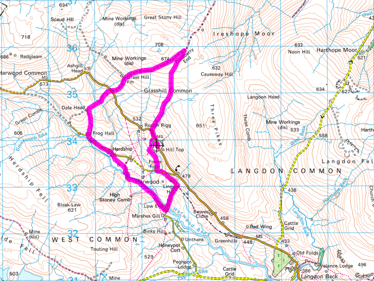
Distance - 6.1 miles Map : OS Explorer OL31 Parking : a lay-by opposite the mast at Hill Top on the B6277 (823 338) | ||
LANDRANGER 92 O/S Crown copyright 2016 CS-30288-W3Z2M1
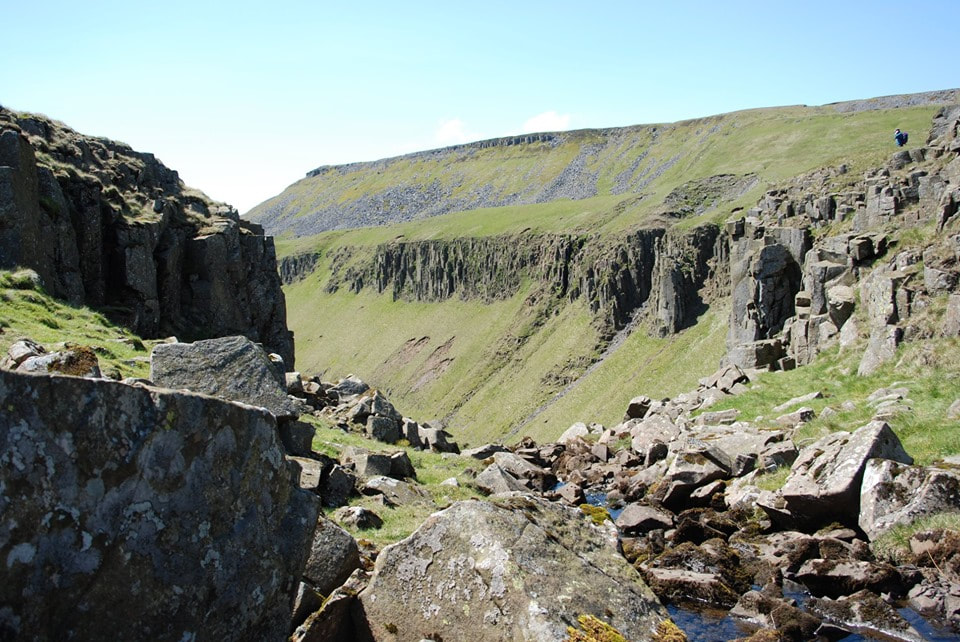
There are a large number of old mine shafts and sink holes in this area so do not attempt the walk in poor visibility. There are also three
crossings of streams without footbridges.
Walk along the verge the short distance to Trough Sike where you will see a footpath sign off to the right. Go through the gate and follow the path upstream. A landslide will soon force you to cross the beck. Choose your place to cross carefully and look for a route back across as soon as you have passed the landslip. In a short distance the route of main beck turns to the left and a small tributary flows straight towards you. Here climb up the bank on your left to walk along the top past as series of grouse butts towards a large sheepfold. Behind you in the distance you will see Mickle Fell with Little Fell to its right. Further to the north are Meldon Hill, Get Dun Fell (with its prominent weather station), Little Dun Fell and Cross Fell (the highest peak in England outside the Lake District).
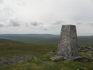
Go around the sheep fold to find the beck, now just a shallow stream, once more. Continue upstream alongside it. Soon a prominent grassy spoil heap will become obvious ahead. Behind it you will find ruins of buildings from old mine works. The peak of Three Pikes is now clear to your right, whilst ahead are a line of grassy mounds containing deep pools. Continue in the same direction. A large cairn should now be clear ahead to your right. Once you can make out a line directly ahead which is the first glimpse of the old road of Grasshill Causeway, begin to work your way over towards the cairn on your right, choosing the driest route possible. As you get close to the cairn you will come to a cut through from the causeway in the bank on your left. Turn and follow it up to the causeway. Here turn right and follow the causeway to the watershed at Coldberry End. If you wish to continue on to the trig point at High Field (708 metres) simply follow the fence on your left for about 10 minutes, alternatively if you would like to look down to Burnhope Reservoir and the valley of Weardale continue along the causeway for another 5 minutes. Should you extend the walk in either of these ways, return to Coldberry End to begin the next stage of the route.
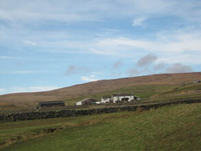
Follow the causeway downhill. In places large amounts of loose stone mean that it is easier and safer to use the grass verges for walking. Pass through a gate and continue on to the B6277. Cross the road to the footpath sign and follow the path downhill with a stream on your right. At the bottom cross a footbridge over Ashgill Beck and follow the path up the next field between a fence and an old wall. Cross a stile into the next field and in the corner ahead go over another stile in the wall on your left. Looking downhill the tops of some trees are visible. Head towards these and the modern barn at Dale Head becomes visible. The path runs over to the left side of the barn and then turns left along the field. Continue through a gate and turn downhill to cross the stream (there is no bridge I’m afraid). Continue downhill to find a stile where the fence and wall meet and on down to pass to the right of a small derelict barn (the white farm house of Frog Hall is further over to your left) and reach the surfaced road at the head of Harwood valley. Turn left until you reach the two farms at Herdship.
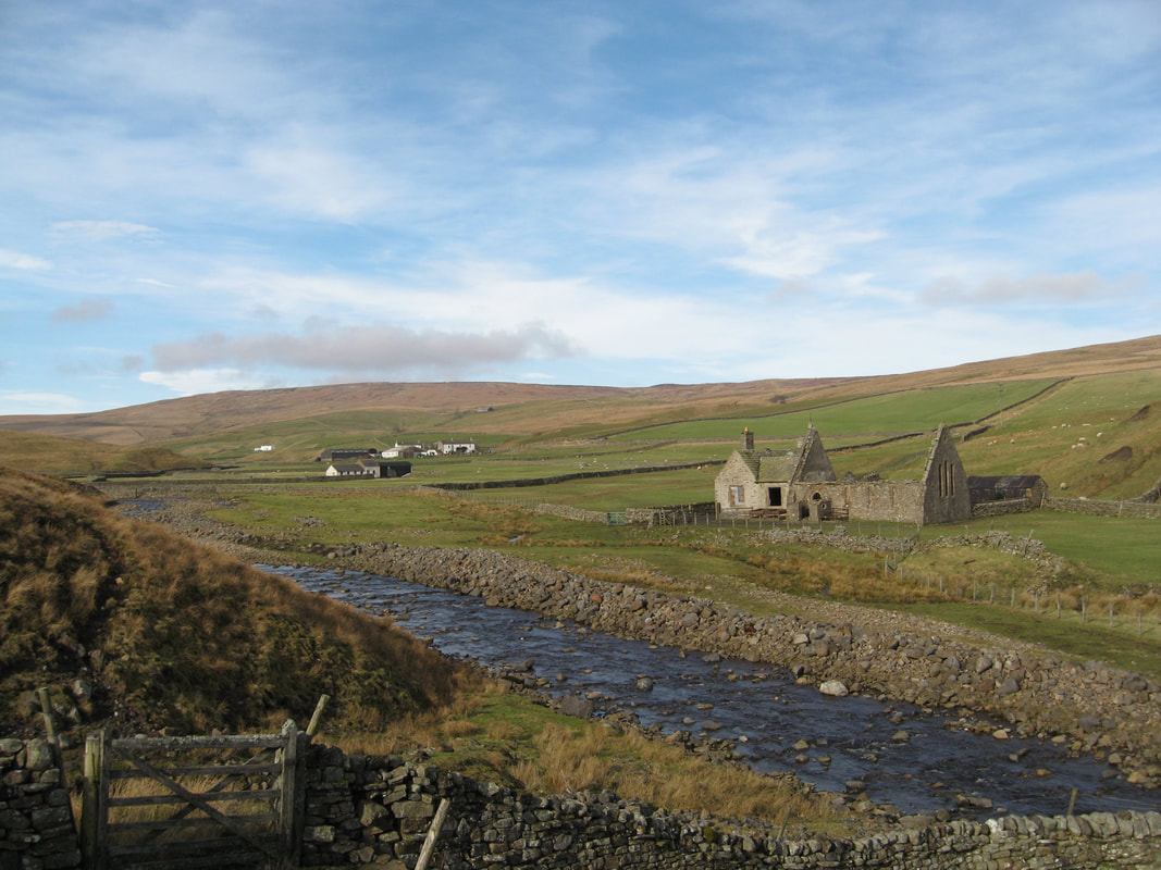
At the farm of Watersmeeting on your right, turn right (following a finger post) into the farmyard and then through a gate on your left to pass between buildings. Ahead of you is a large galvanised gate. Pass through this and cross the field to another gate. Go straight on to cross a stile in the wall ahead, before going across a slab bridge over a sike and rising slightly to reach a track ahead. Here turn right to walk down towards some ruined buildings. These are the remains of Harwood church and school. Pass through a gate on their right out onto the river’s edge and walk along downstream in front of the buildings to reach a substantial footbridge over Harwood Beck.
Rise slightly uphill until you can find a route downstream avoiding the landslip ahead. When the field wall ahead comes into view steadily make your way back down to pass between the beck and the wall. The path follows along the beck side, passing the ruins of Midge Holm before reaching the road at Low End. Turn left over the bridge and follow the road up past the old chapel on your left and eventually Lingy Hill farm on your right to reach a T junction. Here turn left downhill. Just before the first house on your right take the footpath signed on your right. Go through the gate and climb the hill ahead keeping roughly parallel with the B6277 which you can see to your right.Find a gate ahead and continue straight on to find another gate at the back of some old ruins. You are now on a track. Follow it as it angles down to cross Trough Sike at a ford and then swings back up to the B6277. The parking space is just a few yards to your right.
crossings of streams without footbridges.
Walk along the verge the short distance to Trough Sike where you will see a footpath sign off to the right. Go through the gate and follow the path upstream. A landslide will soon force you to cross the beck. Choose your place to cross carefully and look for a route back across as soon as you have passed the landslip. In a short distance the route of main beck turns to the left and a small tributary flows straight towards you. Here climb up the bank on your left to walk along the top past as series of grouse butts towards a large sheepfold. Behind you in the distance you will see Mickle Fell with Little Fell to its right. Further to the north are Meldon Hill, Get Dun Fell (with its prominent weather station), Little Dun Fell and Cross Fell (the highest peak in England outside the Lake District).
Go around the sheep fold to find the beck, now just a shallow stream, once more. Continue upstream alongside it. Soon a prominent grassy spoil heap will become obvious ahead. Behind it you will find ruins of buildings from old mine works. The peak of Three Pikes is now clear to your right, whilst ahead are a line of grassy mounds containing deep pools. Continue in the same direction. A large cairn should now be clear ahead to your right. Once you can make out a line directly ahead which is the first glimpse of the old road of Grasshill Causeway, begin to work your way over towards the cairn on your right, choosing the driest route possible. As you get close to the cairn you will come to a cut through from the causeway in the bank on your left. Turn and follow it up to the causeway. Here turn right and follow the causeway to the watershed at Coldberry End. If you wish to continue on to the trig point at High Field (708 metres) simply follow the fence on your left for about 10 minutes, alternatively if you would like to look down to Burnhope Reservoir and the valley of Weardale continue along the causeway for another 5 minutes. Should you extend the walk in either of these ways, return to Coldberry End to begin the next stage of the route.
Follow the causeway downhill. In places large amounts of loose stone mean that it is easier and safer to use the grass verges for walking. Pass through a gate and continue on to the B6277. Cross the road to the footpath sign and follow the path downhill with a stream on your right. At the bottom cross a footbridge over Ashgill Beck and follow the path up the next field between a fence and an old wall. Cross a stile into the next field and in the corner ahead go over another stile in the wall on your left. Looking downhill the tops of some trees are visible. Head towards these and the modern barn at Dale Head becomes visible. The path runs over to the left side of the barn and then turns left along the field. Continue through a gate and turn downhill to cross the stream (there is no bridge I’m afraid). Continue downhill to find a stile where the fence and wall meet and on down to pass to the right of a small derelict barn (the white farm house of Frog Hall is further over to your left) and reach the surfaced road at the head of Harwood valley. Turn left until you reach the two farms at Herdship.
At the farm of Watersmeeting on your right, turn right (following a finger post) into the farmyard and then through a gate on your left to pass between buildings. Ahead of you is a large galvanised gate. Pass through this and cross the field to another gate. Go straight on to cross a stile in the wall ahead, before going across a slab bridge over a sike and rising slightly to reach a track ahead. Here turn right to walk down towards some ruined buildings. These are the remains of Harwood church and school. Pass through a gate on their right out onto the river’s edge and walk along downstream in front of the buildings to reach a substantial footbridge over Harwood Beck.
Rise slightly uphill until you can find a route downstream avoiding the landslip ahead. When the field wall ahead comes into view steadily make your way back down to pass between the beck and the wall. The path follows along the beck side, passing the ruins of Midge Holm before reaching the road at Low End. Turn left over the bridge and follow the road up past the old chapel on your left and eventually Lingy Hill farm on your right to reach a T junction. Here turn left downhill. Just before the first house on your right take the footpath signed on your right. Go through the gate and climb the hill ahead keeping roughly parallel with the B6277 which you can see to your right.Find a gate ahead and continue straight on to find another gate at the back of some old ruins. You are now on a track. Follow it as it angles down to cross Trough Sike at a ford and then swings back up to the B6277. The parking space is just a few yards to your right.
Langdon Beck Hotel Walk 1 : Cronkley Fell

Save the file to your device and then rename it by taking out the .txt at its end. Your device will now open it as a gpx file
|
Distance - 6.9 or 8.9 miles
Map : OS Explorer OL31 Parking : at the hotel or at Hanging Shaw Car Park (867298) |
| ||
LANDRANGER 92 O/S Crown copyright 2016 CS-30288-W3Z2M1
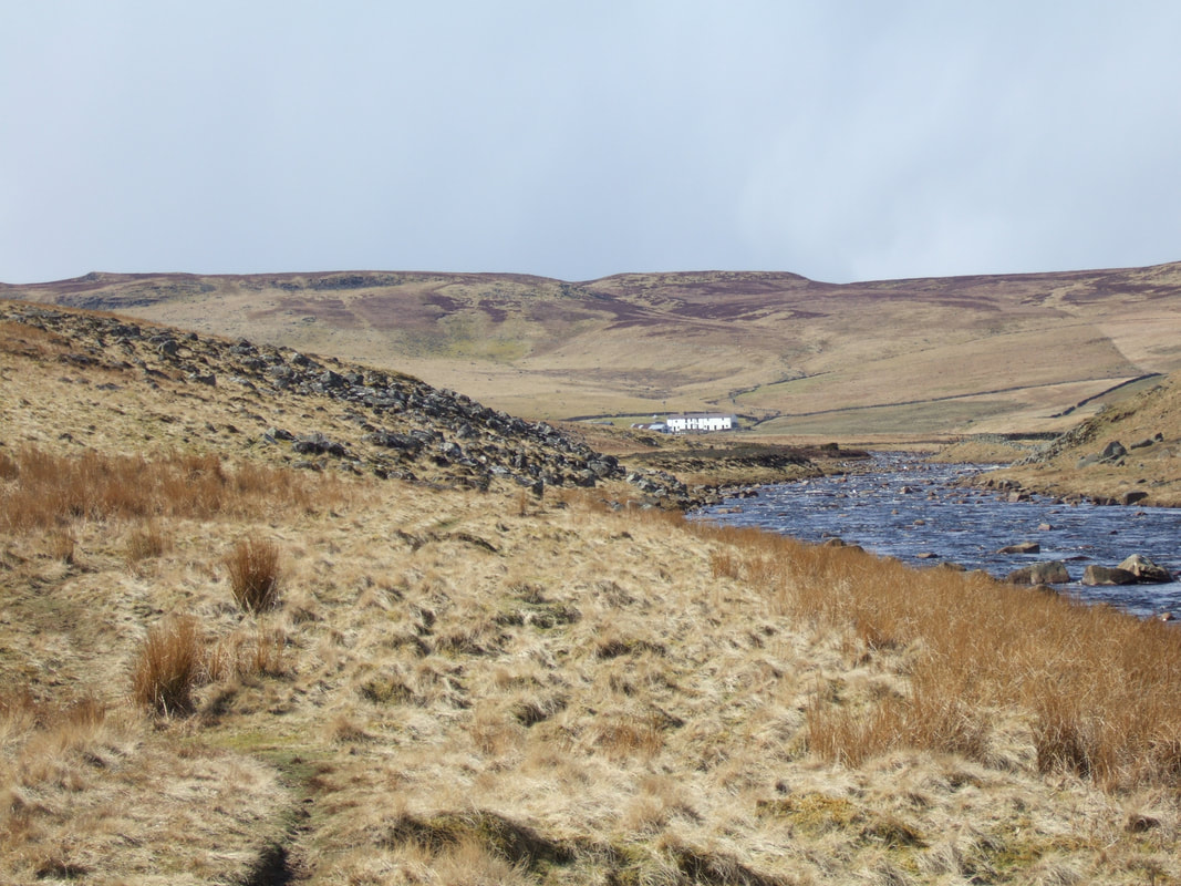
From the hotel turn left down the minor road towards Cow Green. Where Langdon Beck left meets Harwood Beck a bridge to your left takes a footpath off to the west side of Harwood Beck and through a gate into the farmyard of Intake Farm. Take this path through the farmyard and keeping the farm on your right, out again to continue by the beckside. After a short while it rises briefly to run alongside a wooden barrier, just in front of a dry stone wall, before running down to Saur Hill Bridge. Cross the bridge and follow closely to the east side of the beck on what is now the Pennine Way. The beck flows into the River Tees, but your route continues downstream (in places it is forced very close up to the Tees) until you reach a farm bridge over the river.
From Hanging Shaw car park walk down to the main Middleton to Alston road. Turn right along the road for a few yards and then cross over and follow the footpath sign down the drive to Birk Rigg. Before reaching the farm a clear footpath sign leads you around the right of the buildings and straight down the field to a stile. Crossing a mashy section the path rises to follow to the right of a stream, past some barns and a few yards later arrives at a gate on the right. Passing through the gate the path continues across the field to another gate and then left down a steep slope to a farm bridge over the RiverTees.
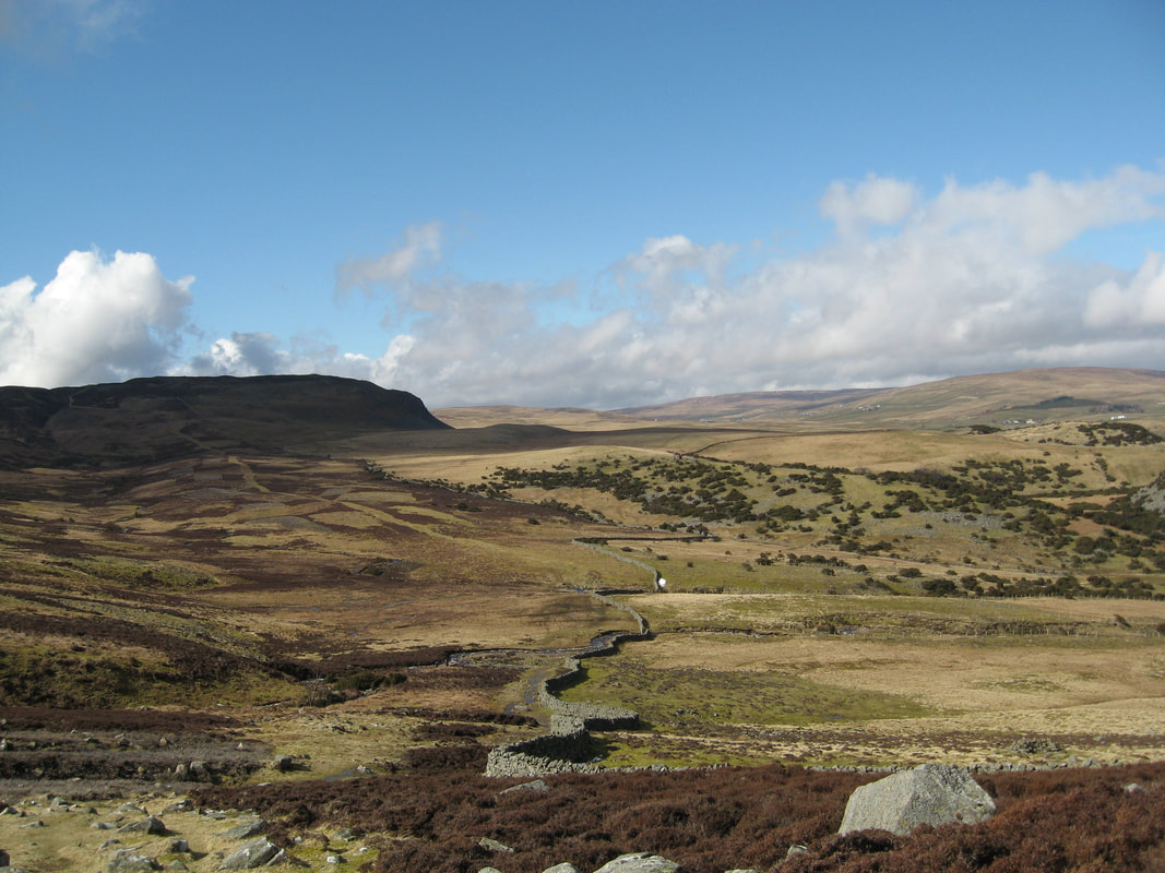
Cross the bridge and follow the track up the slope towards Cronkley Farm, but instead of entering the yard, go right over a stile and down the side of the wall to reach a stile at the bottom of High Crag. The path slants up a steep slope through the rocks and gorse to a hidden stile. From here follow the side of the wall up to a good viewpoint before descending and crossing a stream and a stile. A little way ahead you climb to a guidepost on the crest of the hill. The Pennine Way goes straight on, whilst our path turns right down to a gate in the corner of the pasture. Ahead is Noon Hill and by now the old green track along the valley below is clearly visible. Continue through the gate to stepping stones beyond and on to join the green track at a Nature Reserve sign and turn right. This is an old drovers’ way that was used to drive cattle from Alston to Thisk and the Vale of York. It will lead you up the moor to Cronkley Fell. It is quite a steep climb, but one eased by the views of White Force tumbling down the hillside to your left and of the drove road going on towards Holwick behind you.
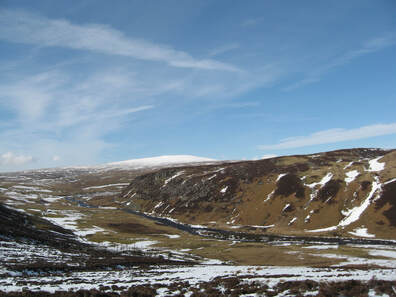
The path eventually reaches open moorland. Continue in the same direction, passing three fenced areas and a number of cairns. Inside these fences sugar limestone ecosystems are being protected from the attention of sheep and rabbits to give them the chance to recover. Look out for the world famous Teesdale Spring Gentian. Its blue spikes appear between April and June. There are more distant views as well. Looking in the distance from south west to north west a range of 2000 feet summits is seen (Mickle Fell, Backstone Edge, Meldon Hill, Great dun Fell, Little Dun Fell, Cross Fell, Round Hill and Herdship Fell). The trig point a few yards to your right on Cronkley Fell is a mere 544 metres.
Cross the plateau of Thistle Green and as you drop down into a basin the first view of Falcon Clints ahead comes into view. Passing here the third fenced area of sugar limestone more frequent cairns appear. The largest, on the edge of the plateau, marks the start of the descent back to the Tees Valley. With Widdybank Fell in front of you and Cronkley Scar to your right, work your way down towards an island in the Tees. You reach the bottom of the slope close to a wall and from here a faint path angles off towards the river but slightly to your right. When you reach the river bank follow it downstream. Quickly the path becomes trapped between the river and Cronkley Scar. For about half a mile you follow this path, through heather, juniper bushes and scree, tight in on the river. Often the route is aided by duckboards in an attempt to conserve the path. Opposite Widdybank Farm (Natural England’s office for the Upper Teesdale National Nature Reserve) the route begins to open up again. The path continues to follow the river for roughly a mile and a half. Finally at a barn look for a gate to the right and, going through it, take the track across the pasture, sticking well to the left of farm buildings, to reach the track to Cronkley Farm by a bridge over the Tees.
To return to the hotel or to Hanging Shaw simply reverse your route from the start of your walk.
From Hanging Shaw car park walk down to the main Middleton to Alston road. Turn right along the road for a few yards and then cross over and follow the footpath sign down the drive to Birk Rigg. Before reaching the farm a clear footpath sign leads you around the right of the buildings and straight down the field to a stile. Crossing a mashy section the path rises to follow to the right of a stream, past some barns and a few yards later arrives at a gate on the right. Passing through the gate the path continues across the field to another gate and then left down a steep slope to a farm bridge over the RiverTees.
Cross the bridge and follow the track up the slope towards Cronkley Farm, but instead of entering the yard, go right over a stile and down the side of the wall to reach a stile at the bottom of High Crag. The path slants up a steep slope through the rocks and gorse to a hidden stile. From here follow the side of the wall up to a good viewpoint before descending and crossing a stream and a stile. A little way ahead you climb to a guidepost on the crest of the hill. The Pennine Way goes straight on, whilst our path turns right down to a gate in the corner of the pasture. Ahead is Noon Hill and by now the old green track along the valley below is clearly visible. Continue through the gate to stepping stones beyond and on to join the green track at a Nature Reserve sign and turn right. This is an old drovers’ way that was used to drive cattle from Alston to Thisk and the Vale of York. It will lead you up the moor to Cronkley Fell. It is quite a steep climb, but one eased by the views of White Force tumbling down the hillside to your left and of the drove road going on towards Holwick behind you.
The path eventually reaches open moorland. Continue in the same direction, passing three fenced areas and a number of cairns. Inside these fences sugar limestone ecosystems are being protected from the attention of sheep and rabbits to give them the chance to recover. Look out for the world famous Teesdale Spring Gentian. Its blue spikes appear between April and June. There are more distant views as well. Looking in the distance from south west to north west a range of 2000 feet summits is seen (Mickle Fell, Backstone Edge, Meldon Hill, Great dun Fell, Little Dun Fell, Cross Fell, Round Hill and Herdship Fell). The trig point a few yards to your right on Cronkley Fell is a mere 544 metres.
Cross the plateau of Thistle Green and as you drop down into a basin the first view of Falcon Clints ahead comes into view. Passing here the third fenced area of sugar limestone more frequent cairns appear. The largest, on the edge of the plateau, marks the start of the descent back to the Tees Valley. With Widdybank Fell in front of you and Cronkley Scar to your right, work your way down towards an island in the Tees. You reach the bottom of the slope close to a wall and from here a faint path angles off towards the river but slightly to your right. When you reach the river bank follow it downstream. Quickly the path becomes trapped between the river and Cronkley Scar. For about half a mile you follow this path, through heather, juniper bushes and scree, tight in on the river. Often the route is aided by duckboards in an attempt to conserve the path. Opposite Widdybank Farm (Natural England’s office for the Upper Teesdale National Nature Reserve) the route begins to open up again. The path continues to follow the river for roughly a mile and a half. Finally at a barn look for a gate to the right and, going through it, take the track across the pasture, sticking well to the left of farm buildings, to reach the track to Cronkley Farm by a bridge over the Tees.
To return to the hotel or to Hanging Shaw simply reverse your route from the start of your walk.
Langdon Beck Hotel Walk 2 : Cow Green & Cauldron Snout

Save the file to your device and then rename it by taking out the .txt at its end. Your device will now open it as a gpx file
|
Distance - 7.5 miles
Map : OS Explorer OL31 Parking : Car Park at Cow Green Reservoir (811 309) |
| ||
LANDRANGER 92 O/S Crown copyright 2016 CS-30288-W3Z2M1
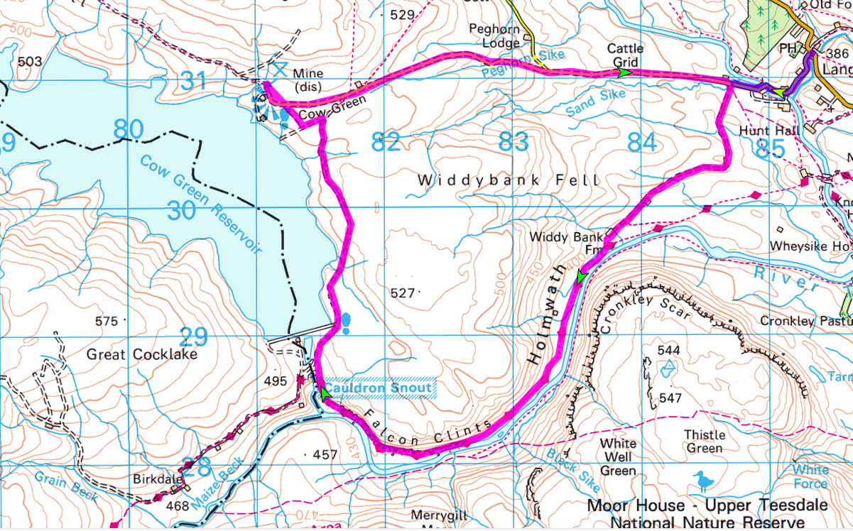
The instructions for this walk are written based upon parking at Cow Green Reservoir, but if you prefer there is space for one or two cars to park where the track to Widdy Bank Farm leaves the Langdon Beck to Harwood road (847309) or you can walk from the hotel (but this significantly increases the amount of road walking). The reservoir was built between 1967 and 1971 to control the flow of the Tees and so to prevent flooding as it approaches the sea. As Cow Green provided an habitat unique for wild flowers the creation of the reservoir caused considerable opposition. Fortunately many of the flowers were saved and transplanted in the area around the reservoir making it a popular place for botanists. It is worth stopping at the information panels to find out more about all aspects of the site.
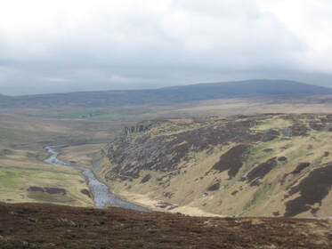
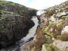
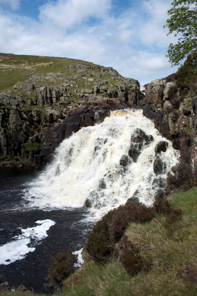
Unfortunately the walk begins with a two and a quarter mile stretch of road walking. However you can walk on the verge for most of the time, the roads are very quiet, there are good views of Teesdale and you are walking downhill ! Walk back down the reservoir access road and when you reach the Langdon Beck to Harwood road turn right (towards the hotel). Continue for almost a mile and just after passing a white painted barn, go over the cattle grid and turn right at the track to Windy Bank Farm at a Moor House, Upper Teesdale Nature reserve sign. Follow the winding track to the white painted Moor House farm and pass through the farmyard. Continue on the track on soft grassland, with the River Tees on your left and the dominant rock face of Cronkley Scar beyond. At a corner steep slopes close in on your right and the path is forced along a narrow route between the river and the slope. There is a short stretch of boulders to scramble over and then a short break before reaching the impressive Whin Sill outcrops of Falcon Clints on your right where there are more rocks along the path. Soon you hear the sound of Cauldron Snout. Where the Tees and Maize Beck meet the waterfall comes into sight.
There is now a scramble up the rocks at the side of the waterfall. Go carefully ! Cauldron Snout is more a series of steps that the water cascades down than a simple drop, and it is made that much more impressive by the fact that you are so close to the water, but if you find the route too challenging you can climb up the heather covered bank – there are faint tracks showing the routes that others have taken. At the top of the fall(s) continue up to meet the Birkdale Farm access road. Here the Pennine Way turns left, but your route continues straight up the right hand side of the dam. Continue ahead until you reach a gate. Go through and turn left on the stony track. After a couple of hundred yards, fork off to the right on a more minor but obvious track until you reach the road Here turn left to return to the car park.
Langdon Beck Hotel Walk 3 : Cow Green to High Cup Nick

Save the file to your device and then rename it by taking out the .txt at its end. Your device will now open it as a gpx file
|
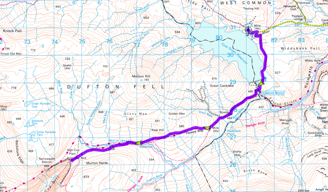
Distance - 13 miles
Map : OS Explorer OL31 Parking : at Cow Green Reservoir car park (811309) |
| ||
LANDRANGER 92 O/S Crown copyright 2016 CS-30288-W3Z2M1
By the car park is an information point identifying the distant peaks such as Great Dun Fell, Low Dun Fell and Cross Fell and outlining the ecology, geology and history of the area. From the car park walk back up the road and take the first path on the right heading roughly south east. Reaching a cross track, turn left and continue to a tarmac track. Go through the gate, turning right and follow this access road to the dam to join the Pennine Way.
If you wish to visit the waterfall of Cauldron Snout keep to the left of the Tees and follow the path down to find the best viewpoint, before returning to the junction of the access road and the Pennine Way.
This time continue along the Pennine Way to drop down and cross the river bridge. Keep left at the junction just over the river (do not take the track back up towards the reservoir). Continue on the path passing Birkdale Farm on your right (one of the farms that was the subject of the ITV documentary ‘Too Long a Winter’ that first introduced Hannah Hauxwell of Baldersdale to the wider public). The path continues along a stony shooters track, passing the ruins of an old mine shop on your left and warning signs for the MOD artillery range for Warcop (don’t worry you do not enter it !) before dropping to and following the attractive beck.
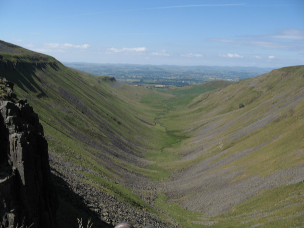
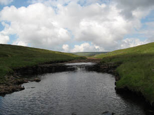
Eventually at 768267 you reach a bridge over Maize Beck. Cross to follow the Pennine Way on the south side of the beck. As you continue Maize Beck eventually swngs away to your right and after a short while the view of High Cup Nick unfolds in front of you - a beautiful ‘U shaped’ glacial valley which is a complete contrast to the moorland that you have just crossed. Its a great place to sit and look in wonder. Having rested and explored the top of the Cup it is time to return, following the outward route back, unless you have a second car waiting for you in the village of Dufton which is four miles further down the Pennine Way.
If you wish to visit the waterfall of Cauldron Snout keep to the left of the Tees and follow the path down to find the best viewpoint, before returning to the junction of the access road and the Pennine Way.
This time continue along the Pennine Way to drop down and cross the river bridge. Keep left at the junction just over the river (do not take the track back up towards the reservoir). Continue on the path passing Birkdale Farm on your right (one of the farms that was the subject of the ITV documentary ‘Too Long a Winter’ that first introduced Hannah Hauxwell of Baldersdale to the wider public). The path continues along a stony shooters track, passing the ruins of an old mine shop on your left and warning signs for the MOD artillery range for Warcop (don’t worry you do not enter it !) before dropping to and following the attractive beck.
Eventually at 768267 you reach a bridge over Maize Beck. Cross to follow the Pennine Way on the south side of the beck. As you continue Maize Beck eventually swngs away to your right and after a short while the view of High Cup Nick unfolds in front of you - a beautiful ‘U shaped’ glacial valley which is a complete contrast to the moorland that you have just crossed. Its a great place to sit and look in wonder. Having rested and explored the top of the Cup it is time to return, following the outward route back, unless you have a second car waiting for you in the village of Dufton which is four miles further down the Pennine Way.